Bikeways Maps Errata
When the Lake Champlain Bikeways publications were prepared we tried hard to avoid errors but we were not perfect as we have found out. This sheet is an attempt to provide the correct information related to situations which have come to our attention. Map corrections are listed first and separately there is a list of conditions that have come to our attention that has resulted in rider confusion or taking the wrong road.
We encourage anyone knowing of other problems to bring them to our attention via email or regular mail:
Lake Champlain Bikeways
1 Steele St. #103
Burlington, VT 05401
info@champlainbikeways.org
Printed Map Corrections
Champlain Bikeways printed map
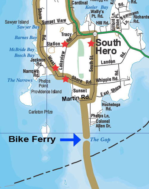
The route to the Local Motion ferry is incorrectly shown in Zone F6 of our old map as going to the south end of South Street. The correct route is shown in the insert to the Stone Castle ride in the Champlain Island Bikeways brochure and is shown below. When proceeding south on South Street proceed past West Shore Road and turn right on Martin Rd., unpaved and the next road on the right. The path to the ferry is on the left at the small parking lot. There is a sign for a fishing access.
In zone G4 just north of Keese Corners, the map shows Sullivan Rd crossing the Interstate and connecting with Davern Rd. This connection does not exist and the closest connection is via Arthur Rd. which crosses less than a mile south as shown on the map.
Champlain Islands Bikeways
A Trail To Two Beaches shows a connection between Coon Point Rd. and Poor Farm Rd. at the south end of the peninsula. This connection does exist but it has not been maintained and the gate at Poor Farm Rd. has been closed. This route should be adjusted to make Poor Farm Rd. and Coon Point Rd. as out and back rides. The Alburg Dunes State Park is at the end of Coon Point Rd.
Points of Rider Confusion
Lake Champlain Bikeways Map
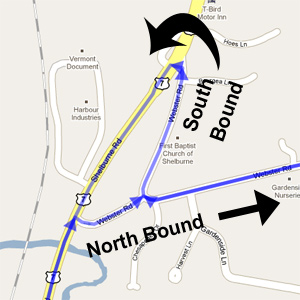 North of Shelburne after the right turn on Webster Rd. there is a situation at the top of the first hill. The route headed north continues east which is straight ahead as shown by the sign. The confusion comes from the fact that signs can be seen for the route headed south which turns right at this point and heads north for a short distance prior to turning left and heading south on Route 7. This is the result of Webster Rd. being one way east leaving Route 7.
Orwell, VT. – It has come to our attention that several of our signs have been removed near the intersection of Routes 22A and 73. The route turns at this intersection. The route uses Route 22A only as much as absolutely necessary because of fast, heavy traffic and frequent places where there is little or no shoulder.